Group News: Hawaiʻi Island Group, Maui, and Oʻahu
Hawaiʻi Island Group
Upcoming Outings
Saturday, August 23
Puʻu Makaʻala Hike in a Natural Area Reserve (E/C/F)
2.5 miles, elevation: 4000’ +/- 300, Moku o Puna
This will be an easy to moderate interpretive hike into a protected Natural Area Reserve old growth intact volcano rainforest with many large old ʻōhiʻa trees, ʻōlapa, and towering hapuʻu tree ferns. The hike will be slow paced as we explore the native plants, ferns, and very interesting ʻōhiʻa trees and a number of endangered plants like the loulu palm. Bring rain gear with your normal day hike accessories. Rapid ʻŌhiʻa Death protocol please. We will meet at Cooper Center in Volcano Village and carpool to the trailhead. Register for the hike by calling Diane Ware at 808-967-8642. Limit 10 due to NAR requirements.
Saturday, August 30
Laʻiku Farm Tour and Service (S/E)
Debbie Ward’s farm, Moku o Puna, Kurtistown
Debbie, longtime Sierra Club advocate, board member and volunteer will give us a tour of her farm after which we will help with farm duties. This outing will be both educational and service in honor of Debbie’s decades of service to our island and the Sierra Club. Mahalo Debbie! Bring work clothes, sturdy shoes, water and lunch for a picnic. Sign up with Debbie at 808-769-2403.
Leader: Diane Ware
Volunteers and Paid Staff Sought for Key Hawaiʻi County Positions
By Debbie Ward, Hawaiʻi Island Group Member
For the past five years, I have had the honor of serving as a commissioner on the Public Access, Open Space and Natural Resources Commission (PONC) for the County of Hawaiʻi. However, my term—along with the terms of several other Commissioners—will come to an end this December. We are reaching out now to ask for community members with an interest or background in Hawaiian history, culture, archaeology, land use planning, or related fields, to consider serving as PONC commissioners.
PONC was created by the voters of Hawai’i County to preserve public access, open space, and natural and cultural resources. It is uniquely funded by dedicating 2% of the County’s annual property tax revenues, allowing the public to work with the Commission to identify and advocate for the purchase and protection of important lands.
The kuleana of advising the County on preserving lands cherished by our communities is not a small one. It takes time and commitment to read, research, visit, and evaluate nominated properties. But the reward is deep and lasting—the knowledge that you’ve helped protect our ʻāina for generations to come.
If you are interested in applying, please click here to download the application form. Once completed, please scan and email it to Micah.Alameda@hawaiicounty.gov.
Additionally, the County’s Finance Department has announced openings for paid positions supporting PONC, including managerial and land acquisition roles. These can be found on the County’s website.
Keauhou Aquifer System Adaptive Management Plan Says “Drill, Baby, Drill”
By Chuck Flaherty, Hawaiʻi Island Group Chair and Cindi Punihaole, Hawaiʻi Island Group ExCom Member
The Keauhou Aquifer System
The Keauhou Aquifer System (Aquifer) provides freshwater to much of North Kona, on the leeward side of the Hawaiʻi Island (see map below). It is part of Hawaiʻi’s Public Trust Doctrine, which recognizes water as a resource that must be protected for present and future generations.

For decades, there has been growing concern about what is the Aquifer’s “sustainable yield”—the maximum rate of water withdrawal that won’t compromise human and ecological needs or violate public trust protections. Yet because the underground geology and hydrology of the Aquifer remains largely unknown, any estimate of sustainable yield is, at best, an educated guess. The true impact of increased withdrawals on culturally and ecologically important resources is also unknown.
To better understand the Aquifer and its sustainable limits, we recommend watching a lecture by Dr. Jonathan Scheuer of Kahālāwai Consulting LLC and former Sierra Club of Hawaiʻi Political Committee Chair.
What many don’t realize is that the Aquifer includes massive underground freshwater flows—natural rivers that travel from mauka to makai and discharge into the ocean. These freshwater flows are critical to constitutionally protected traditional and customary practices, as well as the health of anchialine ponds, shoreline springs, fishponds, and pristine coral reef ecosystems.
National Park Service Petitions State Commission on Water Resource Management
In 1974, the community-based “Spirit Report” laid the foundation for what is now Kaloko-Honokōhau National Historical Park (Park), emphasizing the importance of freshwater flow from mountain to sea in preserving the area’s cultural and ecological integrity.
In September 2013, the National Park Service (NPS) petitioned the Commission on Water Resource Management (CWRM) to designate the Keahou Aquifer as a Water Management Area (WMA), in order to protect these essential freshwater flows. In 2015, the NPS filed a follow-up Petition for Declaratory Orders, warning that:
Existing and proposed groundwater withdrawals threatened cultural and natural resources essential to the park's mission, purpose and values.
Despite years of discussion, there was no plan to protect non-consumptive uses of water (such as ecosystem and cultural health).
The legal threshold for WMA designation is not scientific certainty, but reasonable determination—and the Precautionary Principle requires action in the face of possible harm.
Still, the petition was denied. Since then, multiple large water wells have been approved and drilled, pulling millions of gallons of freshwater daily from the Aquifer—without understanding the consequences to public trust resources.
The Plan to Not Plan
Ten years later, in July 2025, CWRM voted to develop a “First-Generation Keauhou Aquifer System Area Groundwater Adaptive Management Plan” (AMP).
Public testimony was overwhelmingly opposed. Traditional practitioners and community members criticized the AMP as a toothless response—nothing more than a plan to monitor impacts after new wells are drilled. Testifiers argued it gives developers a green light to proceed, unchecked.
To put it plainly: the AMP is a plan to drill first, ask questions later.
Let’s use an analogy. Imagine you and your neighbors live on a highway with no speed limit. Over time, the number of cars increases, and so do traffic accidents and fatalities caused by speeding. There’s a commission with authority to set legal speed limits for highways, but in order to trigger that process, a formal petition must be submitted. So, concerned for your community’s safety, you and your neighbors file a petition requesting a speed limit for the highway.
But the speeders push back. They claim a speed limit would violate their freedom to drive as fast as they want. They leverage political influence and backroom pressure to sway the commission. In the end, your petition is denied.
To deflect public criticism and give the appearance of action, the commission decides to spend some money to create and adopt a plan—not to set a speed limit, but to monitor the traffic and track how many people continue to get injured or killed.
So what did you and your neighbors get for your effort? No speed limit. No plan to set a speed limit. Just a plan to observe the consequences of unchecked speeding. Meanwhile, the speeders get to keep doing exactly what they’ve been doing all along—with no accountability.
That’s what’s happening with the Keauhou Aquifer. Instead of designating it as a Water Management Area—akin to setting a speed limit—CWRM has chosen to observe and record the damage while allowing further development. The AMP avoids regulation and allows drilling to continue. It is, in effect, a “Drill, Baby, Drill” plan.
A Glaring Omission: Recycled Water
One of the most serious flaws in the AMP is its failure to include recycled water as a critical alternative.
Hawaiʻi County is under a federal mandate to upgrade the Kealakehe Wastewater Treatment Plant to produce R-1 quality recycled water. This mandate also requires more homes to be connected to [upgrade will also] expand the area covered by the sewer system, likely doubling wastewater flows—and the potential supply of safe, usable recycled water.
Yet the AMP fails to incorporate this future resource. CWRM must begin requiring that new well permit applications include the use of recycled water to reduce the burden on the Aquifer and take a more holistic approach to water resource management.
Do What Should Have Been Done
The Sierra Club Hawaiʻi Island Group will continue public outreach and advocacy efforts, urging CWRM to reject the AMP and do what should have been done ten years ago: designate the Keauhou Aquifer System as a state Water Management Area.
The time for delay is over. The health of our cultural resources, ecosystems, and freshwater future depends on real action—not monitoring while the damage is done.
Maui Group
Kuʻu Home Paeahu
By Lucienne de Naie, Maui Group Chair
“We seek nourishment in that other, deeper geography where the true names of our ‘āina are sung by the stones themselves.” - Kīhei De Silva, Song of Stones


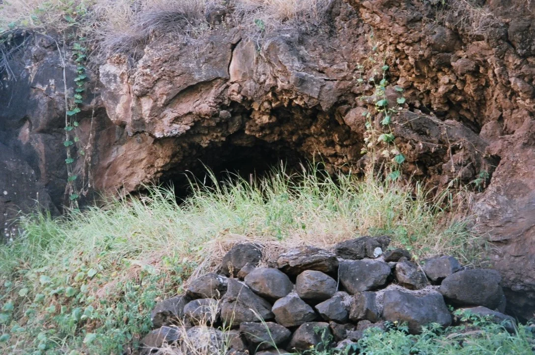


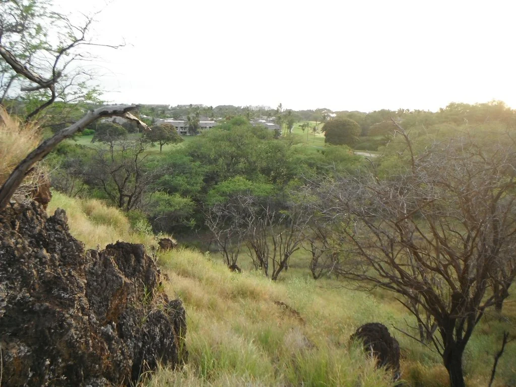
Kuʻu home o Paeahu—“my home in Paeahu”—a loving reference commonly used about one’s ancestral home place, is rarely heard today. Yet for over six hundred years, thousands of Hawaiian families called the ahupuaʻa of Paeahu home. Up until now, very few Hawaiian places have been preserved in Paeahu (modern day “Wailea”), but thanks to legal efforts by a group of allies, including the Sierra Club Maui Group, that may soon change—and the land itself may once again have a voice.
The name Paeahu is said by some to refer to “numerous ahu” or stone piles, used to dry and preserve fish along South Maui’s traditional fishing grounds. But modern histories of the area often begin with the arrival of plantation and ranches in the 1850’s. Long overlooked, along with the place name Paeahu, are the stories of those who once walked the rocky hills and wiliwili forests—stories of origin, and stories of loss.
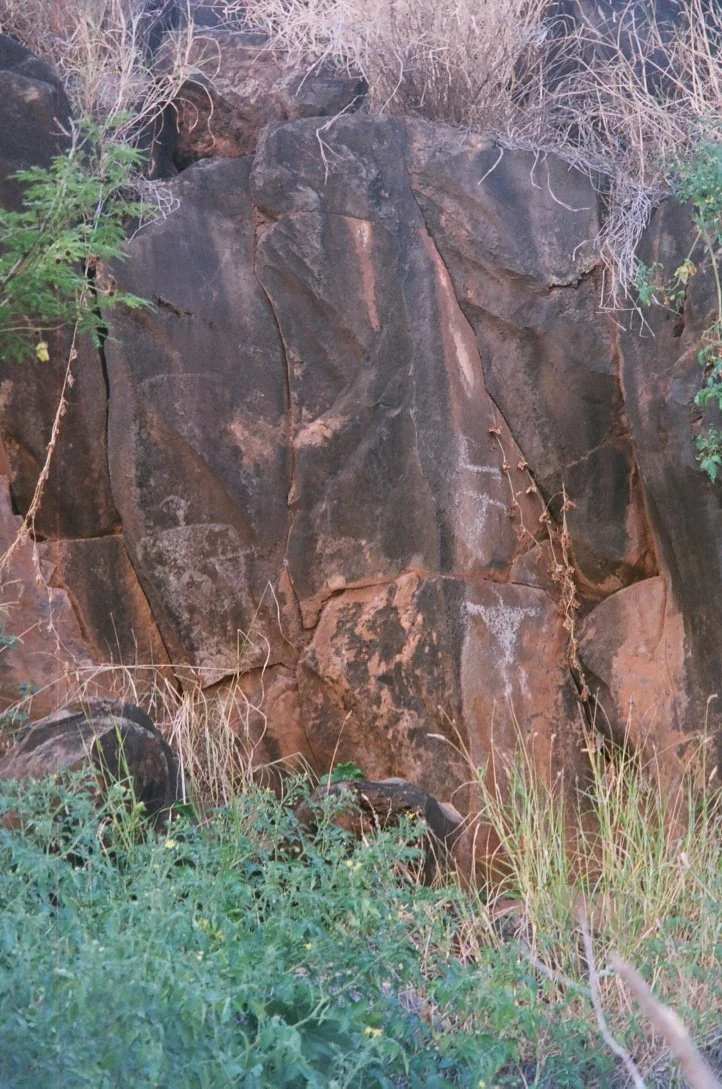
Paeahu holds rock shelters used nearly 600 years ago, some still marked by petroglyphs, yet there is no attempt to preserve and learn from the surrounding cultural landscape. Forgotten place names, archaeological finds, and old maps would suggest muliwai (estuaries) along Paeahu’s rugged coastline. Identifying and restoring them as productive fisheries, could help reverse the drastic loss of marine life catalogued since urbanization.
The traditional village of Kahamanini (today renamed “Wailea Beach”) was mentioned in 1840’s land grants. Its massive puʻu one (sand dunes) served as elaborate burial grounds for hundreds of traditional Hawaiian internments. Overlooked by a heiau and surrounded by many archaeological sites, every feature of this ancient village has since been demolished or relocated to build the Grand Wailea Hotel. Yet its history remains a vital part of Paeahu’s past—and future.
In modern times, the ahupuaʻa of Paeahu and many of the place names associated with it have been pushed aside and replaced by the appropriated brand name known as “Wailea,” a name and vision introduced by the Wailea Development Company in the 1960s. Their plan was to transform 1,500 acres of so-called “barren land” into a luxury resort zone—complete with golf courses, high-end condos, and exclusive gated communities. The original plan even promised beach access, worker housing, parks, schools, and a trolley system to serve local residents.
As modern “Wailea” emerged from the rugged, rocky landscape of Paeahu, the land was forever altered. The ancient King’s Highway and its memories was bulldozed out of existence, replaced by a more “convenient” resort access road. Limited local parking access meant Paeahu’s ancient fishing grounds and white sand beaches were mostly reserved for resort guests. Most natural gulches were filled, their seasonal flows rerouted and replaced by pipes under roads and golf courses. Sculpted volcanic formations, thousands of years old ago, were blasted and bulldozed into artificial ponds, manicured golf greens and lavishly landscaped view lots. Magnificent sand dunes that had sheltered kanaka maoli burials for over half a millenium, were flattened—the burials and surrounding sand relocated to more “convenient” spaces, or simply removed—to locations unknown.
Promises made half a century ago to benefit the local community—affordable homes, public parks, a transit system—have faded, just like the old names of Paeahu, Kahamanini, Kuhulu, and Niukauila.
Still, some people remember the land of Paeahu and don’t want its real story forgotten.
As the last 150 undeveloped acres envisioned to become the “Wailea Master Planned Resort” comes up for modern review, the Sierra Club Maui Group and allies Maui Tomorrow Foundation, and Hoʻoponopono O Makena, are urging the courts to take a hard look at the Environmental Review for the 900-unit “Wailea Phase II” luxury development.
“It’s our last chance to have the story of Paeahu be heard,” said Carol Lee Kamekona, a board member of both Maui Tomorrow and Hoʻoponopono O Makena, who is a recognized lineal descendent of the Paeahu ahupuaʻa. “We know there are other ‘ohana whose roots are in the ‘āina of Paeahu. We must ensure our story is not lost! To do that requires having a physical place to show our story, not just pictures in a book."
Clare Apana, Sierra Club Maui Group Conservation Committee co-chair, is a cultural researcher and practitioner who has long advocated for protection of iwi kupuna (traditional Hawaiian burials.) “We have lost so many pieces that make up the moʻolelo (story) of Paeahu, and we have so many important questions that need answers,” Apana observed. “ We must have a plan for these Paeahu lands that allows the ‘āina and the cultural landscape to remain—to allow those answers to be found”.
“The current developers, Ledcor Corporation of Canada, claim that their local consultants are telling them there just isn’t a cultural landscape in their Paeahu lands,” says Stacey Alapai, who works as a community organizer with Maui Tomorrow. “But I have talked to lots of knowledgeable kupuna who feel differently—it just seems they are not being heard.”
Help keep the Paeahu story alive. Tax deductible donations for legal expenses can be made to: “The Sierra Club Foundation” with Maui Group in the memo line and mailed to PO Box 791180, Paia HI 96779. Please contact Lucienne de Naie, huelogrl@icloud.com, if you wish to donate by credit card or other means.
Upcoming Outings
Saturday, August 9
Makawao Forest Trail Maintenance Day (S)
Upcountry, 4 miles
Join us for a rewarding day of trail maintenance in the beautiful Kahakapao Forest Reserve in Makawao! The Kahakapao Krew will be working from 10am-1pm to preserve and improve the trails that wind through this lush forest, ensuring they remain accessible, safe, and enjoyable for everyone. We will be hosted this month by the Maui Mountain Bike Coalition! Volunteers will help with tasks such as excavating trail sides, removing excess dirt, and clearing overgrowth to ensure the trail is safe and accessible. Tools like McLeods and Pulaskis will be provided, and volunteers will be trained on how to use them safely. This is a hands-on opportunity to help mālama ‘āina and contribute to the long-term sustainability of our natural areas. Please bring sturdy, closed-toe boots, water bottle to stay hydrated, protective clothing (long sleeves, hat, bug spray, sunscreen), work gloves if you have them (we'll also provide some). Join our Facebook Group "Kahakapao Krew" to get the latest updates! If you have any questions or need more information, please contact Raina at 330-289-1087.
Leader: Raina Myers, raina.myers@sierraclub.org
Sign up
Sunday, August 10
Waiheʻe Coastal Dunes and Wetlands Refuge (C/E)
Waihe‘e, 3 miles
This area was acquired by HILT to keep it from development. Easy 3-mile loop along coast and through forest. Covered shoes recommended on this rocky coast. There are archaeological features, unspoiled views, and we may see whales, monk seals, turtles, native birds, and native plants. We will stop for a snack and to enjoy the views.
Leader: Annie Schultz, acm_schultz@hotmail.com or 808-344-6628
Sign up
Sunday, August 10
Old Hana Hwy in Huelo
Huelo, 2 miles, moderate/strenuous
Today's Hana Highway replaced the more winding Ke Ala Loa or "Kings trail" roadway that once threaded its way through forests and streams. Remnants of this kingdom-era road still exist in today's Huelo community. This hike will explore one section of this forgotten road with the hopes that it can be re-opened for future recreational and cultural use. No EMI waiver needed. All on state land or neighborhood lands with permission. Trail clearing tools (cane knife/small saw, loppers) welcome, some will be provided. Terrain is overgrown and includes some steep, possibly muddy sections. Bring sturdy footwear with good grip, gloves, water, sunscreen, and snack. Meet 9:30am at top of Door Faith Road (at Hana Highway).
Leader: Lucienne de Naie, huelogrl@icloud.com
Sign up
Friday, August 15
Ancient trails of Palauʻea Part 2
2 miles, moderate/strenuous
The Palauʻea lands of Wailea 670 have over 16 sections of rare and mysterious stepping stone trails used to guide the people of old who called Palauʻea home. Our outing will explore one of the longest sections of traditional stepping stone trails still intact (70 + individual stones), as well as the impressive ahupuaʻa boundary marker it leads to. Rugged terrain, with scratchy lantana bushes. Great adventure. Bring water, completed Honuaʻula Partners waiver, closed toe shoes/boots, long pants. Optional to bring hiking sticks/poles and a camera. Meet 4pm by grey gate at the top of Kaukahi Road in Wailea.
Leader: Lucienne de Naie, huelogrl@icloud.com
Sign up
Saturday, August 23
Wailua Iki Stream Hike (C/E)
East Maui, 6 miles
Moderate hike above Hāna Highway through beautiful forest on winding, muddy, jeep road. Pools, waterfalls and lush plant life. The group may decide to swim. Bring appropriate footwear, sunscreen, lunch, and water. Meet at 8am at Haʻikū Community Center. EMI WAIVER REQUIRED (see emi.html) - must email name, address and phone number to jackie.thomas@mahipono.com at least one week in advance. Limit: 15.
Leader: Rob Weltman, robw@worldspot.com
Sign up
Sunday, August 24
Kapalua Coastal Trail Hike and Welcome Back to Our Beautiful Kōlea (C/E)
West Maui, 3.5 miles
Meet in the Honokahua (DT Fleming) Beach Parking Lot, left side, at 8am. We will walk along the coastal path, a combination of asphalt, gravel, and rocky trail. This should be a great opportunity to photograph our beautiful kōlea (Pacific Golden Plover) as they return from their 3,000-mile migration from their breeding grounds on the Arctic tundra. After a stop at Kapalua Bay, we will return to Honokahua (DT Fleming) Beach. Although the footing can be rough in places, this is an easy three and a half mile roundtrip hike. There are restrooms at each end of the walk. There is an optional detour to Makāluapuna Point on the way back to see the jagged rock formation known as Dragon’s Teeth and to walk the labyrinth for those interested. Swimming and snorkeling are excellent at both DT Fleming Beach and Kapalua Bay, so bring appropriate gear if you wish. Snack/lunch on the beach at Kapalua Bay. Bring water and reef-safe sun protection.
Leader: Annie Schultz, 808-344-6628
Sign up
Saturday, August 30
Hāmākua Mālama Service Outing (C/E/S)
Ha‘ikū, 2 miles
Help clear away abandoned rubbish from gulches in Ha‘ikū’s Hāmākua Coastal Preserve and re-plant native species. Tools, snacks, trash bags, etc will be provided. Co-sponsored by Mālama Hāmākua.
Leader: Lucienne de Naie, huelogrl@icloud.com
Sign up
Oʻahu Group
Boardwalks and Boglands: Sierra Club's Ongoing Legacy at Mount Kaʻala
By Reese Liggett, Oʻahu Group Outings Leader
The statewide Natural Area Reserves System (NARS) was established to permanently protect specific land and water areas in Hawaiʻi that support relatively unmodified communities of native flora and fauna, as well as significant geological sites. Today, there are 20 reserves across five islands— and Mount Kaʻala has long been a favorite destination for Sierra Club Conservation Outings.
In fact, Sierra Club volunteers made up the majority of the workforce that installed the redwood boardwalk along the cross-bog route in the late 1980s—much of which still exists today. This boardwalk plays a crucial role in protecting sensitive bog ecosystems by keeping hikers and other visitors from widening the trail to avoid the area’s persistent muddy conditions.
Mount Kaʻala, the highest peak on Oʻahu at 4,026 feet, has a distinctive flat summit and is easily recognizable by the single FAA/DOD radome perched near the top — visible off to the left as you drive from Wahiawā toward Haleʻiwa.
After three hours of slogging conservation work, outing participants were rewarded with a guided tour along the boardwalk through this one-of-a-kind landscape. What makes it so special is the boggy environment, created by rainwater trapped atop nonporous Hawaiite lava under cool, rainy, and windy cloud forest conditions — all of which stunt the growth of many plants. Remarkably, the area is composed of approximately 95% native plant species. (Hawaiite is a fine-grained volcanic rock formed by the rapid cooling of lava that is moderately low in silica and enriched in alkali metal oxides — source: Wikipedia.)
A big mahalo goes to state NAR researcher Nayma Kahn and the provided transportation, and to the volunteers for their conservation efforts.
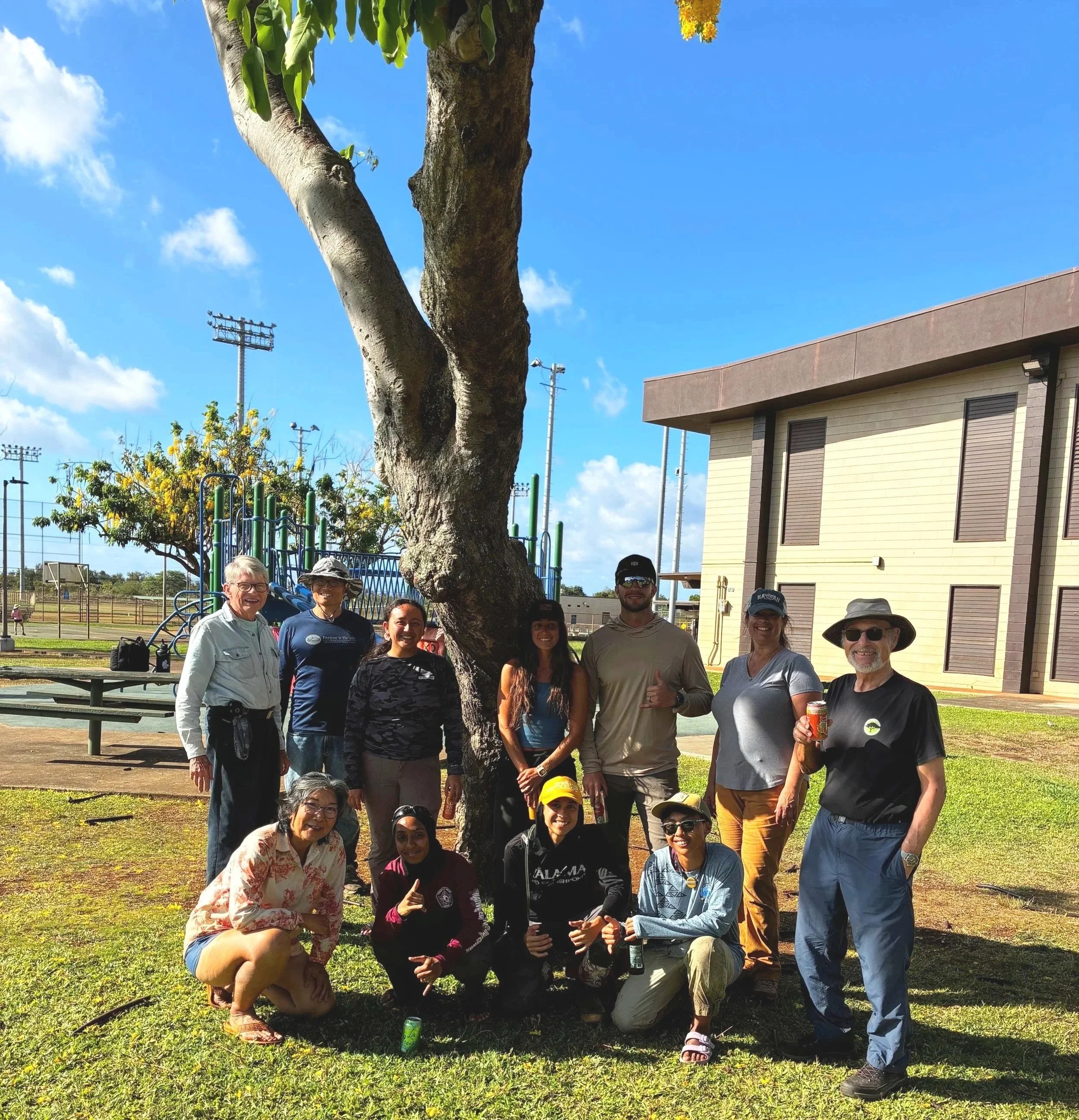
Photo: Ten Sierra Club members and prospective members supported conservation of the Natural Area Reserve atop Mount Ka`ala with 30-person-hours of blackberry-cane removal and herbicide application after a scenic ride up the FAA Access Road in a state van. They were under the leadership of Nayma Kahn (State NAR Researcher, front second from left, and Outings Leaders Suzan Harada (front, left) and Reese Liggett (rear left). Hawaiʻi Chapter Director, Wayne Tanaka (rear, second from left), and Oʻahu Group ExCom members Honuʻāina Nichols and Kiara Bacasan (kneeling right) participated. Other participants were (standing from right) Dennis Lind, Elizabeth Nicol, Mike Lesko, Karena Pelino, and Monica Texiera.
Upcoming Outings
Sunday, August 10
Mālama Tree Crew: Pālehua Service Project
Join us to clear debris, weed, and water around 75 newly planted native trees in the Akupu Enclosure in the Gill Ewa Lands (GEL). GEL encompasses 1,600 acres in the southern tip of the Wai‘anae mountains dedicated to preserving the land's important biological, cultural, economic and historical resources. The Akupu Enclosure provides habitat for endangered ʻelepaio to nest. Meet at 7:45am at Makakilo Community Park, near the top of Makakilo Drive. We will work from 8am-11pm. To help you prepare, we suggest wearing long sleeves, pants, and closed toe shoes. Although we provide tools, you might prefer to bring your favorite tool and gloves. Remember to pack water, a snack, and insect repellent. Reservations are required at least one day prior, so please RSVP to sherrycassetta@gmail.com with your full name and phone number.
Leader: Sherry Cassetta
Thursday* to Sunday, August 14-17
Puʻu Makaʻala Natural Area Reserve System Service Trip, Hawaiʻi Island
We will be working with staff from the Department of Land and Natural Resources (DLNR) Natural Area Reserve System (NARS), focusing primarily on removing invasive ginger from the reserve. This aggressive species threatens native forest plants that rely on protection from invasive competition. Accommodations will be provided at the DLNR baseyard volunteer house in Hilo, which includes hot and cold running water and bunk beds. If interested, email Clyde with your name, phone number, and email address by Thursday, July 31. Co-leader: Curtis Kawamoto.
*This trip requires a Thursday afternoon afternoon arrival and Sunday evening departure.
Sunday, August 17
Wāwāmalu Beach Service Project
Help return Wāwāmalu Beach to its native/natural status after years of off-road abuse and inattention. Seed collection and sowing, as well as removal of invasive plants on tap. Both light and heavy tasks—your choice. Bring closed-toe shoes/boots, gardening gloves, sunscreen and water flask (iced refill available, no plastic water available). Meet 8am at the southwest access area just off to the left from the northeast driveway to Sandy Beach. Limited to 24 participants out of concern for the delicate planting environment. Participants under 18 require a parent or guardian. Please reserve your spot by emailing wrliggett@yahoo.com.
Leaders: Reese Liggett and Suzan Harada